East Ilsley is unusual in that it was never formally enclosed, so that remnants of the medieval strip field system persisted well into the 19th century. Although many of the original strips were combined into larger fields by purchase of adjacent strips, much of the south west part of the parish continued to be dominated by narrow strips of land (around 0.5 to 1 acre in size) owned by smaller landowners. The tithe map of 1840 clearly shows these strips of land. To make more practical fields for farming, some of the small farmers in that part of the parish rented adjacent strips to those that they owned.
The pattern of land ownership and farming changes significantly over the period covering the 18th through the 20th century. For this time span there is a reasonable amount of documentary evidence to show these changes. We will be adding more information on aspects of these changes in due course, including –
- Field and furlong names
- Glebe lands, belonging to the church
- Building a land holding in the 18th century, using written descriptions of land holdings
- Tithe map of 1840
- Lord Overstone’s estate map of 1858
- Valuation survey of 1910
- Farm survey of 1941
Field and furlong names
Because of the survival of so much of the strip system, we know the names of the individual furlongs from the 1840 tithe map. We also know the names of the 3 Fields used in the medieval crop rotation system. [Note: in this case “Field” refers to the large block of furlongs, not the individual small strips. The approximate locations of the Fields are shown in the small inset map]. The map below is taken from a tracing of the tithe map and shows each individual furlong as a solid block of colour – the number in each furlong links to the list of furlong names below. The individual strips within each furlong are also shown, where their locations have survived to the time of the map.
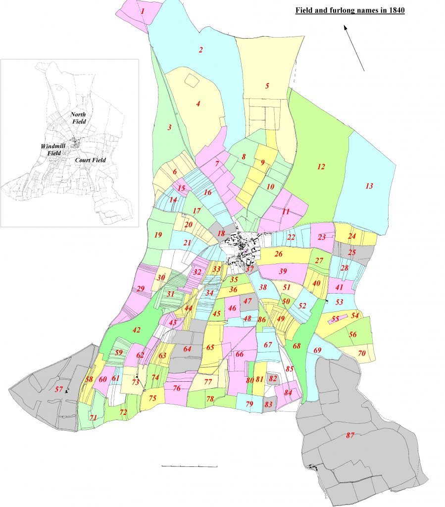
Furlong names (from the 1840 tithe map)
1. Kates Gore & Gore Park
2. Sheep or Common Down
3. Abingdon Lane Several Down
4. Abingdon Lane Cow Down
5. Several Down
6. Down Furlong
7. Abingdon Lane North Furlong
8. North Field
9. Middle Furlong
10. Prestwell Furlong
11. Prestwell Fields
12. Compton Several Down
13. Compton Cow Down
14. Furlong below the Mill
15. Bow Furlong
16. Abingdon Lane South Furlong
17. Lye Hill Furlong
18. Home Close
19. Hodcott Hedge Furlong
20. Mill Furlong
21. Hodcott Footway Furlong
22. Yew Tree Furlong
23. Hither Gravel Furlong
24. Gravel Furlong
25. Compton Footway Furlong
26. Drove Acre Furlong
27. Bow Furlong
28. Long Furlong
29. Ends Down Furlong
30. Greenwoods Bye
31. Yew Tree Hedge Furlong
32. Elm Stile Furlong
33. Town End Furlong
34. Beech Tree Hedge Furlong
35. Luke’s Barn Piece
36. Newbury Lane Bottom Piece
37. Best’s Close
38. Newbury Lane Piece
39. Black Hedge Furlong
40. Furlong behind Black Hedge
41. Short Furlong
42. Windmill Down
43. Yew Tree Hill
44. Ball Pit Road Furlong
45. Further Furlong
46. Middle Furlong
47. Newbury Lane Hill Piece
48. Beedon Footway Furlong
49. Dytches Furlong
50. David’s Mere
51. Black Hedge Piece
52. Shrill Down Furlong
53. Barn Piece
54. Knowl Furlong
55. Bush Piece Furlong
56. Ashridge Bottom Furlong
57. Woolvers Farm
58. Lower Bellweather Furlong
59. Goldborough Furlong
60. Upper Bellweather
61. Further Goldborough
62. The Hatchet Furlong
63. Banniger
64. Banniger Bottom
65. Beech Tree Furlong
66. Frogfield Bottom Furlong
67. Red Hill Furlong
68. Shrill Down
69. Ashridge Pieces
70. Ridings Furlong
71. Jarvis’s Grounds
72. Wick Furlong
73. Palmer’s Barn
74. Moors Bottom
75. Kiln Piece
76. The Breach Furlong
77. Banniger Hill
78. Furlong behind Banniger
79. Further Hooks
80. Nutfield Down
81. Nearer Hooks
82. Money’s Close
83. Beedon Ground
84. Halfpenny Catch Furlong
85. Mile Stone Piece
86. Picked Piece Newbury Lane Hill
87. Ashridge Farm